AI Unleashes Hyperspectral Satellite Data to Combat Methane Emissions
In a pioneering collaboration, researchers from the University of Oxford, in partnership with Trillium Technologies’ NIO.space, have developed a cutting-edge tool that leverages artificial intelligence (AI) to automatically detect methane plumes on Earth from orbit using hyperspectral data. This breakthrough has the potential to identify ‘super emitters’ of methane, facilitating more effective strategies to combat greenhouse gas emissions. The research findings, published in the journal Nature Scientific Reports, mark a significant step in the global fight against climate change.
The Urgency of Methane Emissions:
While much attention is given to carbon dioxide (CO2) emissions in Net Zero targets, addressing methane emissions is equally critical. Methane is a potent greenhouse gas, being 80 times more effective in trapping heat than CO2, although it has a comparatively shorter atmospheric lifetime of 7 to 12 years. Rapid action to reduce methane emissions from anthropogenic sources could yield immediate results in slowing global heating and improving air quality. Experts estimate that achievable reductions in methane emissions could potentially prevent nearly 0.3°C of warming over the next two decades. Existing Challenges in Methane Detection:
Until now, mapping methane plumes from aerial imagery has been a challenging and time-consuming task. Methane is transparent to both the human eye and the spectral ranges used in most satellite sensors. Even when satellite sensors operate in the correct spectral range, data is often obscured by noise, necessitating laborious manual approaches for effective plume identification.
Hyperspectral Data and AI: A Synergistic Solution:
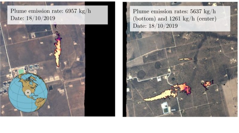
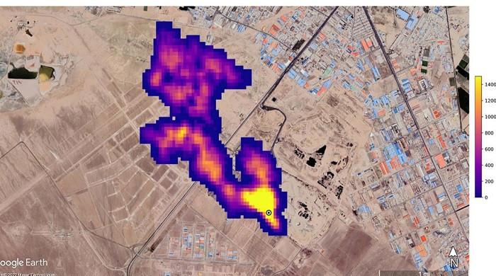
The researchers at Oxford overcame these challenges by developing a machine-learning tool that detects methane plumes in hyperspectral satellite data. Hyperspectral satellites, with their ability to detect narrower bands, make it easier to tune into the specific signature of methane and filter out noise. However, the increased data volume poses a challenge, which is addressed through the application of AI.
Training the Model:
The model was trained using 167,825 hyperspectral tiles, each representing an area of 1.64 km², captured by NASA’s AVIRIS aerial sensor over the Four Corners area of the USA. Subsequently, the algorithm was applied to data from other hyperspectral sensors in orbit, including NASA’s new hyperspectral sensor EMIT attached to the International Space Station, providing near-global coverage.
Impressive Results and Open Sourcing:
The model exhibited an impressive accuracy of over 81% for detecting large methane plumes, surpassing the accuracy of previous methods by 21.5%. Additionally, the false positive detection rate for tile classification saw a notable improvement, decreasing by about 41.83%. To encourage further research in methane detection, the researchers have open-sourced both the annotated dataset and the code used for the model on GitHub.
Potential Onboard Operation and Future Endeavors:
Looking ahead, the researchers are exploring the possibility of the model operating directly onboard satellites, allowing for instant detection and follow-up observations. Professor Andrew Markham, the supervisor for the research, envisions a future where a swarm of satellites collaborates autonomously, with weak initial detections serving as tip-off signals for others to focus on specific locations.
Funding and Collaborative Initiatives:
The project received funding from the European Space Agency (ESA) Φ-lab through the ‘Cognitive Cloud Computing in Space’ (3CS) campaign and was conducted as part of the Trillium Technologies initiative Networked Intelligence in Space (NIO.space).

Conclusion: A Paradigm Shift in Climate Monitoring:
In the face of climate change, the integration of AI with hyperspectral satellite data represents a transformative approach to independently and globally validate the production and leakage of greenhouse gases. The success of this method in methane detection opens avenues for its extension to other pollutants. The ultimate ambition is to run these approaches directly onboard satellites, enabling real-time detection and strengthening our collective efforts in mitigating the impact of climate change. The researchers’ commitment to open-sourcing their work emphasizes a collaborative approach to tackle one of the most pressing challenges of our time.